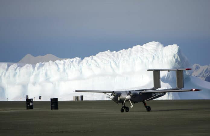
A specialized team has arrived at Rothera Research Station to test the new Windracers ULTRA autonomous drone in Antarctica. If successful, this new drone platform could be a game-changer for the British Antarctic Survey’s scientific capability on the continent. It would allow for more science to be done at a lower cost and with a lower carbon footprint than traditional crewed aviation.
The Windracers ULTRA UAV is designed for extreme environments like Antarctica and is a fully autonomous, twin-engine, 10-metre fixed-winged aircraft that can carry up to 100 kg of cargo or sensors up to 1000 km. It incorporates a high level of redundancy and can continue to fly even if one of the engines or components is damaged or fails. Moreover, it’s designed to be fixed in the field with a minimal number of parts.
The ULTRA UAV has a sophisticated autopilot system called Masterless, which was developed and patented by Distributed Avionics. This allows it to safely take off, fly, and land with minimal ground operator oversight. One of its biggest advantages is its lower-carbon impact compared to traditional crewed aviation, making it a key player in BAS’ plans to reach net zero by 2040.
If implemented, the drones would be used primarily for airborne scientific surveys, taking advantage of the platform’s flexible configuration for a range of scientific instruments. The British Antarctic Survey conducts most of its survey work with Twin Otter aircraft. However, drones could provide significant benefits in terms of flight time and geographic coverage while reducing CO2 emissions per flight hour by around 90%.
Using UAV drones for long-term aerial surveys is becoming more popular due to their lower cost and improved safety. This approach also allows for the collection of more accurate and detailed scientific data.
Moreover, by employing AI-driven SWARM technology, multiple drones could be used together as a single, coordinated system. This method has a broad range of applications in various scientific fields, such as geology, atmospheric science, glaciology, and the study of ocean ecosystems.
For example, in this season’s testing phase, the Windracers ULTRA drone will be used to conduct surveys of environmentally sensitive areas, assess the marine food chain, investigate tectonic structures, assess glaciological structures, and test an atmospheric turbulence probe for studies of boundary layer processes coupling ocean and atmosphere.
“Demonstrating that UAVs can robustly and routinely collect an array of different data is really exciting for the future of Antarctic science,” said Dr. Tom Jordan, a geophysicist from British Antarctic Survey who specializes in airborne data collection. “Polar science urgently needs extensive new high-resolution datasets to understand the ways the Antarctic ice sheet is changing and how this will impact communities around the world. This is our first step toward unlocking those logistical barriers.”
This project is being funded by Innovate UK’s Future Flight 3 Challenge, which is part of a pilot program called ‘Protecting environments with uncrewed aerial vehicle swarms.’ The ultimate goal of this program is to demonstrate how advanced drone technology can be used to collect environmental data in Antarctica. This is an innovative and exciting project that has the potential to revolutionize the way we study and protect our environment.
